You are using an out of date browser. It may not display this or other websites correctly.
You should upgrade or use an alternative browser.
You should upgrade or use an alternative browser.
Medicine wheels
- Thread starter John A.
- Start date
Well give us a history lesson.....
Sent from my SM-J727V using Tapatalk
Sent from my SM-J727V using Tapatalk
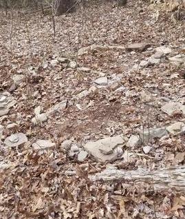
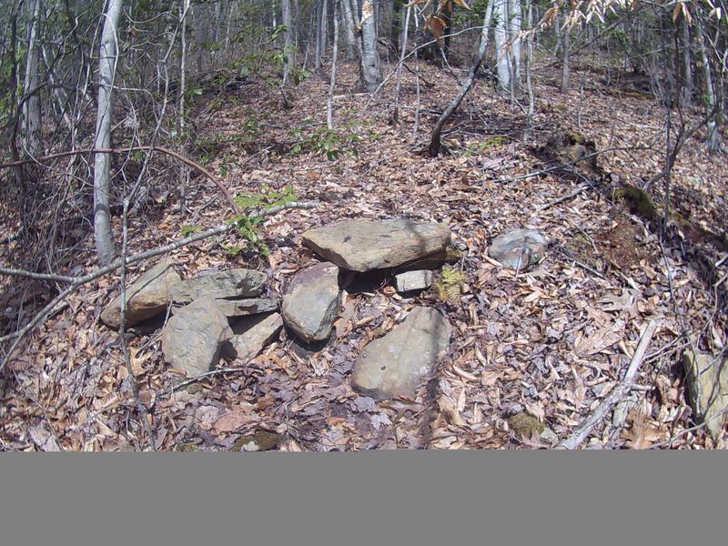
Medicine wheels are often found in special places. Ceremonial places. Not necessarily only used by shaman, but often they are.
This one may be Cherokee, but could've possibly been Creek, perhaps Ridgetop Shawnee or Quadrule depending on who you ask or even maybe even Etowah mound builders considering there are many documented mounds and rock walls near the area and they go back several thousand years.
But regardless, many native American tribes have medicine wheels all across the continent.
Their importance is the circle and the cross. Balance and harmony.
The circle is like the circle of life. Birth, life, death, never ending.
The 4 directions of the earth and what that symbolizes. East, West, North, South.
When used for healing, they don't treat the symptom but to help find the cause of the problem. Often caused by shortcomings in spiritual terms.
More here if you want to take a few minutes to read it (it's short) :
https://www.tokenrock.com/explain-medicine-wheel-131.html
Thanks for sharing John. I had never heard of a medicine wheel. Live and learn.
There are a lot of neat things in that general area.
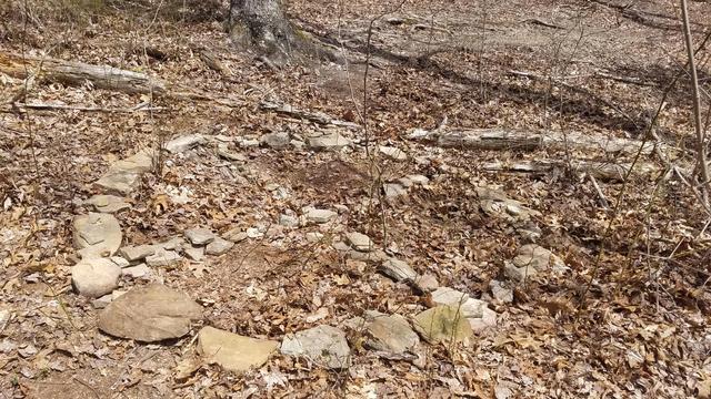
There are multiple rock walls. Some that goes up and down the hill with the slope. Others that go side to side against the slope.
The ones that go side to side are a lot like the old mayan walls that they had built up for planting to help retain water better on the steep hill sides.
One is really special. On the side that you can see, is about 2 foot tall (what you can still see of it today) and the uphill side was either back filled or if it was filled by erosion naturally, even with the top of the walls, which by natural means of erosion, would probably take 10000 years to fill in over 2 feet of earth but there are no records of activity in the 200 years that is on record.
I'm not certain whether it was natural erosion or done by man. I'm going to guess natural erosion basing that there are some trees above the wall that are easily many hundreds of years old and 3 foot or more in diameter of old growth forest.
Sorry, this is the best photo that I can find of it at the moment and shows just how much the upper side has filled in even with the top of the wall. I actually found this by accident squirrel hunting when I was about 12 years old because I got turned around some and was a ridge farther over than what I thought and I remember thinking oh crap, where did this come from? Then my mind went to "oh crap, where am I at?" LOL I could hear the cars on the highway and figured it out in a few minutes where I needed to go to get back but was still a neat find.
There is a place in Georgia that is on the national register called Track Rock that has a lot of the same characteristics as this area does. And why you should probably be able to understand why I won't tell people where it is. You're welcome to read more about that here if you'd like:
https://peopleofonefire.com/track_rock_archaeological_zone.html
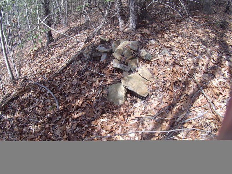
Also a lot of rock mounds.
I have always thought the mounds were burial sites and there are a lot of them unless it had been farmed and the rocks were just stacked up to get out of the way. Regardless, the rocks didn't stacked up by itself.
Here are just two of the mounds, but there are easily more than 50 around the top of that ridge.
Only a few people have seen this or know where it is and we don't advertise because we don't want the area bothered by either professional grave robbers (archeologists) or anyone else. We have always treated the area with the respect that we think it deserves and if anyone were to ask me where it is, will not get the right answer anyway.
hint: It's really in Nancy Pelosi's back side.
There are a few other strange things up there that I can't explain. A few ditches that appear and disappear and in my almost 50 years I have never seen a drop of water flowing through them. Meaning, I think that something may have been mined there at one time. I know for certain there is also blue clay in the area, which is rare.
And there is another place where literally thousands of rocks have been dumped over the hill and are strewn out all the way down to the creek.
Whatever took place in that area where the pictures were taken, was on a pretty big scale for all that work to have went into it.
There are multiple rock walls. Some that goes up and down the hill with the slope. Others that go side to side against the slope.
The ones that go side to side are a lot like the old mayan walls that they had built up for planting to help retain water better on the steep hill sides.
One is really special. On the side that you can see, is about 2 foot tall (what you can still see of it today) and the uphill side was either back filled or if it was filled by erosion naturally, even with the top of the walls, which by natural means of erosion, would probably take 10000 years to fill in over 2 feet of earth but there are no records of activity in the 200 years that is on record.
I'm not certain whether it was natural erosion or done by man. I'm going to guess natural erosion basing that there are some trees above the wall that are easily many hundreds of years old and 3 foot or more in diameter of old growth forest.
Sorry, this is the best photo that I can find of it at the moment and shows just how much the upper side has filled in even with the top of the wall. I actually found this by accident squirrel hunting when I was about 12 years old because I got turned around some and was a ridge farther over than what I thought and I remember thinking oh crap, where did this come from? Then my mind went to "oh crap, where am I at?" LOL I could hear the cars on the highway and figured it out in a few minutes where I needed to go to get back but was still a neat find.
There is a place in Georgia that is on the national register called Track Rock that has a lot of the same characteristics as this area does. And why you should probably be able to understand why I won't tell people where it is. You're welcome to read more about that here if you'd like:
https://peopleofonefire.com/track_rock_archaeological_zone.html
Also a lot of rock mounds.
I have always thought the mounds were burial sites and there are a lot of them unless it had been farmed and the rocks were just stacked up to get out of the way. Regardless, the rocks didn't stacked up by itself.
Here are just two of the mounds, but there are easily more than 50 around the top of that ridge.
Only a few people have seen this or know where it is and we don't advertise because we don't want the area bothered by either professional grave robbers (archeologists) or anyone else. We have always treated the area with the respect that we think it deserves and if anyone were to ask me where it is, will not get the right answer anyway.
hint: It's really in Nancy Pelosi's back side.
There are a few other strange things up there that I can't explain. A few ditches that appear and disappear and in my almost 50 years I have never seen a drop of water flowing through them. Meaning, I think that something may have been mined there at one time. I know for certain there is also blue clay in the area, which is rare.
And there is another place where literally thousands of rocks have been dumped over the hill and are strewn out all the way down to the creek.
Whatever took place in that area where the pictures were taken, was on a pretty big scale for all that work to have went into it.


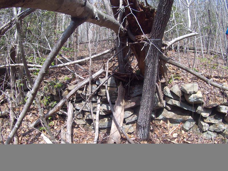
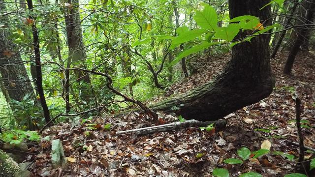
There is also a guide tree up there too. And it points back toward the rock wall, but is still a ways from it. They used those broken trees as street signs and to point you in the right direction if you just know where they're at and what to look for.
I love your pictures Dj. That's right up my alley. That sure is beautiful country.
I love your pictures Dj. That's right up my alley. That sure is beautiful country.